IPIN2017 Exhibition free admission
Japanese Page is here.
This year we invited 16 industries/organization to IPIN2017 Exhibition. This will be a good opportunity for IPIN attendants to know the latest developments of the leading companies in indoor positioning and indoor navigation.
Date and Time
Sep. 20 13:00-18:25
Sep. 21 09:00-17.40
Location
Conference Hall (Hokkaido University, Sapporo, Japan
https://www.hokudai.ac.jp/introduction/campus/hall/
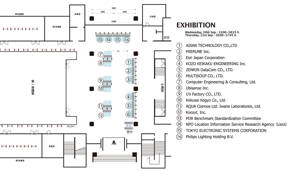
Exhibitors


Exhibition content (Alphabetical)
"Wing Earth" Point Cloud / Fast Editing tool
WingEarth is a tool for editing massive point cloud, and it can handle over 10 billion points.
It has various filtering functions such as "Low density filter", "Height filter", "Ground filter".You can easily remove unnecessary points.
The "Edge extraction" function is useful for grasping shape of an object and tracing lines.By using this function, your work efficiency will rise.
In addition, WingEarth has "Object extraction" function and "Point cloud grouping" function.The management of massive point cloud data becomes effective.
You can also build 3D models from point cloud data by creating meshes of walls or ceilings.
Inquries
Akira Ono, Research and Development Dept.
Email: at_wingearth@at45.aisantec.jp
Tel: +81-52-950-7500
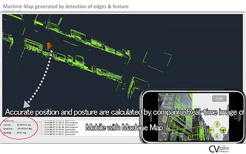
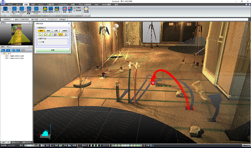
Developing Indoor positioning technology using 3D image map
Introduction of vehicle self-poitioning technology in 3D space using a 3-dimensional map consisting of 3D map & feature object with unique values ( under development).
Proposal of mobile positioning technology using indoor video 3D dimensional map , data desiminataton technology and 3D geo-spatial video of Indoors.
Inquries
Yayoi Iwane
Email: hello@aquacosmos.co.jp
Tel: +81-11-643-0872
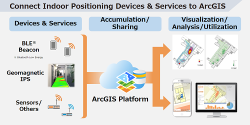
ArcGIS
ArcGIS is a GIS platform that maximizes your ability to utilize digital maps and support making decision swiftly and rationally.
Creating floor map, visualizing and analyzing indoor location data, and utilizing the results with outdoor data - ArcGIS can handle all of them in a single platform.
Various products, SDK, and API allow flexible system development including integrating other IPS platforms.
Inquries
Email: gisinfo@esrij.com
Tel: +81-3-3222-3941
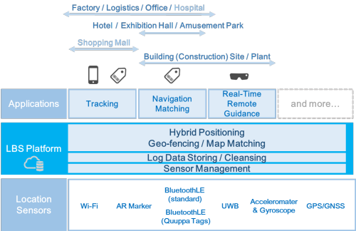
KKC LBS Platform
KKC LBS Platform can achieve indoor and outdoor seamless positioning with optimal accuracy according to the application and budget.
As a form of delivery, we can offer "Positioning Module (SDK) type" to be incorporated in customer's own system, "Package type(Remote support, flow line analysis)" which can be easily started using upper application function as a set.
Inquries
Business Solution Department
Email: genavis_lbs@kk-grp.jp
Tel: +81-3-3288-5900
![]()
DF.sensor: Visualizing Crowd Activity Using Wi-Fi Signals
DF.sensor is an IoT sensor that senses Wi-Fi and BLE signals to visualize crowd activity or asset tracking. For crowd activity, DF.sensor uses Wi-Fi signals from smartphones without the need to preinstall applications. People or assets can also be tracked by using BLE tags/beacons. DF.sensor has been deployed in shopping malls, business premises, convention centers, and can be used to monitor daily conditions and to detect abnormal situations.
Inquries
Email: info@koozyt.com
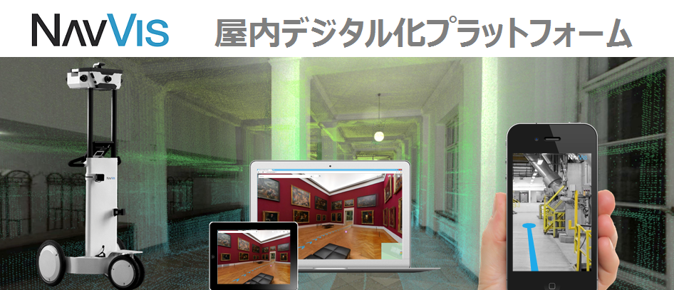
NavVis, 3D Indoor Mapping and Navigation Platform
Everything starts with an excellent map. NavVis' accurate turn-by-turn navigation enables you to create 3D indoor maps easily at low cost, navigate and explore indoors like never before. Virtual indoor applications are seamlessly integrated with the physical world through custom content and applications.
Inquries
Business Dev. Dept. NavVis team
Email: navvis@kke.co.jp
Tel: +81-3-5318-3092

About Lisra
Lisra is engaged in the research and development of technologies and services related to location information and spreading awareness to society. Cooperation with public organizations such as the national government and local governments, universities, private enterprises, volunteers, etc. will provide opportunities for information exchange to form new unprecedented communities. In addition, we are helping to return the latest research results to society through results obtained by demonstration tests. In this exhibition, Lisra's recent activities such as disaster prevention field and activities of digital marketing research group using indoor position information technology will be introduced. We are waiting for the participation of those interested.
Inquries
Email: info@lisra.jp
Tel: +81-52-968-2527
MIERUNE MAP & FOSS4G Tools
MIERUNE MAP is web map service based on original design of OpenStreetMap. Introduce example that can be used for various system with FOSS4G (Free and Open Source Software for Geospatial) tools.
These technologies support to visualizing and analyzing for location data.
Inquries
Kosuke ASAHI
Email: info@mierune.co.jp
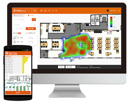
Indoor Localization Solution: iField indoor
visualizes movement of humans, vehicles, things(products, tools), machines in facilities such as factories, warehouses, plants, constructions, hospitals, and so on. By the work situation of the indoor facility is grasped by points, lines, surfaces, and body, the situation of the work is surfaced.
Inquries
Email: info@multisoup.co.jp
Tel: +81-3-3518-9013

PDR Challenge in Warehouse Picking
It is necessary for us to share common measures as PDR related R&D is getting highly active worldwide. For instance, description of the performance should be unified in spec sheets and scientific papers. However, different measures from absolute positioning methods such as GNSS, Wi-Fi, and BLE are required for PDR because it is a method of relative positioning. PDR Benchmark Standardization Committee was established in 2014 as a platform of the grassroots activity for discussing those issues. This year, PDR Benchmark Standardization Committee has organized PDR Challenge in Warehouse Picking. The result will be announced in IPIN 2017.
Support Organizations (38):
Asahi Kasei Corporation, Asia Air Survey Co., Ltd. (Y. Minami), INTEC Inc., MTI Ltd., KDDI R&D Laboratories, Inc., KOKUSAI KOGYO CO., LTD., SHIBUYA KOGYO CO., LTD., Koozyt, Inc., GOV Co., Ltd., SITESENSING, inc., Sharp Corporation, Sugihara Software and Electron Industry Co., Ltd. (SSEI), ZENRIN DataCom CO., LTD., Information Services International-Dentsu, Ltd. (ISID), TOYO KANETSU K.K., IBM Japan, Ltd., Hitachi, Ltd., Frameworx, Inc. (S. Watanabe), MULTISOUP CO.,LTD., Milldea, LLC, Murata Manufacturing Co., Ltd., MegaChips Corporation, Recruit Lifestyle Co., Ltd. (K. Ushida), RICOH COMPANY, LTD., Rei-Frontier Inc., Aichi Institute of Technology (K. Kaji), NARA Institute of Science and Technology (NAIST) (I. Arai), Kanagawa Institute of Technology (H. Tanaka), Keio University (S. Haruyama, N. Kohtake, M. Nakajima), Kyushu University (A. Shimada, H. Uchiyama), University of Tsukuba (T. Kurata), Tokyo Institute of Technology (S. Okada), Nagoya University (N. Kawaguchi), Niigata University (H. Makino), Ritsumeikan University (N. Nishio), National Institute of Advanced Industrial Science and Technology (AIST) (T. Kurata, M. Kourogi), Human Activity Sensing Consortium (HASC), Location Information Service Research Agency (LISRA)
Inquries
Takeshi Kurata, AIST, Japan
Email: t.kurata@aist.go.jp
Tel: +81-29-861-5789
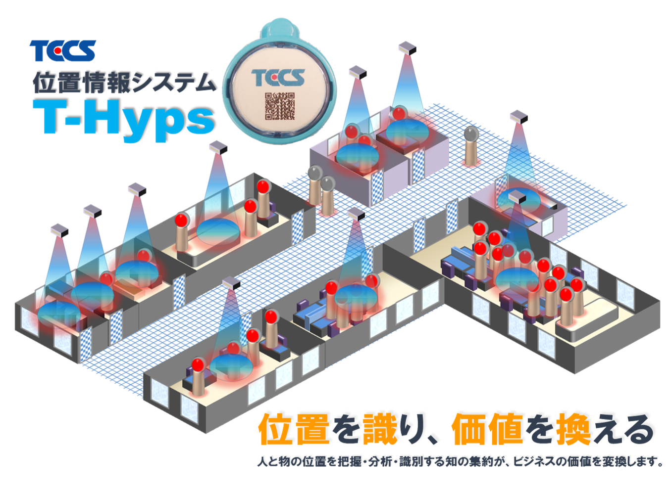
"T-Hyps” Location information system
This position information system, the name of T-Hyps provided by Tokyo Electronic Systems, serves to know the position of the thing in the following fields:
- workers movement watching in the office room or facility area
- members arrival and departure watching in the support for help needed persons and welfare institution
- searching persons or things or prevention for
- constructing the safe and trusted circumstances in the office or welfare institution TX module announcing the position is tiny and light weight in order not to disturb every day work and activity.
This system is assured and guaranteed for working only in Japan.
Inquries
sales department
Email: sales@tecs.toshiba.co.jp
Tel: +81-44-548-5185
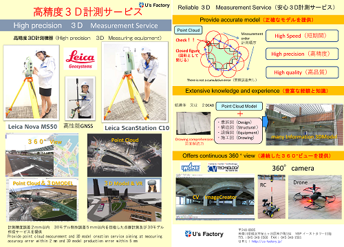
High precision 3D Measurement Service
Provide point cloud measurement and 3D model creation service aiming at measuring accuracy error within 2 mm and 3D model production error within 5 mm
I perform an indoor measurement, an outdoor measurement and make the 3D model of a building, engineering works from the point group and have many results in Japan
Inquries
3D Measurement Service: Takuya Hayashi
Email: info@us-factory.jp
Tel: +81-45-348-1560
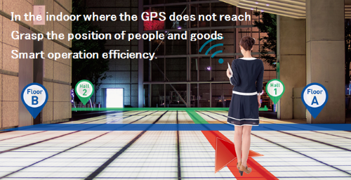
Indoor management solution
We will acquire highly accurate location information in real-time in facilities and in underground shopping centers where GPS does not reach, and realize movement support and facility management.
Inquries
Web-GIS division
Email: contact_indoor@zenrin-datacom.net
Tel: +81-3-6860-7411
Contact
Yuki Akiyama akiyama@multisoup.co.jp